To Paramonas (CT-AP)
You’ll be met at Corfu airport and transferred to your accommodation in Paramonas. The afternoon may be spent on the beach.


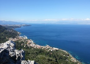
From Paramonas to Stavros and Benitses (CT-04)
A sharp climb early in the walk takes you over the coastal ridge, with great views, and inland to the villages of Ano and Kato Pavliana. Footpaths and tracks take you down through villages until you cross the Messongi River Valley.
You continue through a heathland valley to the village of Strongili, where the Trail heads uphill again, on an old cobbled way which leads to Komianata and Stavros. After a section of road you follow the old Agi Deka water springs down to the village of Benitses.
walking time/distance: 6h / 18km
ascent/descent: 650m
start/finish: Paramonas / Benitses

From Stavros (Coyevinas) via Agii Deka summit to Pelekas (CT-05)
You’ll be taken to the starting point in Stavros village. The walk starts with a delightful footpath skirting Agii Deka Mountain and leading to Ano Garouna, from where you make a very sharp ascent to the summit of Agii Deka, Corfu's second highest free-standing peak. Here, an abandoned monastery in a walled garden makes an ideal rest stop.
Your way continues down a cobbled mule path to Agii Deka village then along minor roads and tracks to Sinarades, where you might like to visit the Folk Museum (depending on opening times) and admire the picturesque architecture of this large village.
Alleyways and a track lead to Aerostato, one of the island's most famous viewpoints, then the Trail leads along undulating tracks with very fine views over the west coast and inland to Pelekas.
walking time/distance: 6h / 17.5km
ascent/descent: 650m
start/finish: Stavros / Pelekas


From Pelekas to Liapades (CT-06)
Half an hour's downhill walk takes you to Myrtiotissa, named ‘the loveliest beach in the world’ (now used by nudists) and the monastery. Climbing now, you have to regain the height you have lost (and more!), with a steep ascent on a gravel and concrete track. The west coast views are spectacular.
Passing the village of Vatos, the terrain levels out and your way crosses the Ropa valley.You will ascend again to the village of Giannades and on into olive-blanketed hills, where tracks lead to Liapades, an ancient village full of lovely old mansion houses.
walking time/distance: 7h / 23km
ascent/descent: 600m / 800m
start/finish: Pelekas / Liapades


The Roman Way from Liapades to Agios Georgios (CT-07)
The walk starts with a sharply ascending footpath which immediately brings you high above sea level towards Paleokastritsa. You quickly cross the main road and head into the hills again, using a network of lovely cobbled footpaths. A climb of about an hour takes you to the centuries old village of Lakones and Bella Vista Viewpoint ('the best view in Europe').
One kilometre of unavoidable and sometimes busy road here, to cross the village, but the spectacular views make up for it! The Trail then heads across olive groves to Krini (from here you can opt to visit the Byzantine castle Angelokastro), through 'Lily Valley' and on down one of Greece's most remarkable footpaths, the Roman Way, which zigzags down a sheer cliff. The way continues down an olive grove track and along the seashore to the resort of Agios Georgios.
walking time/distance: 5h / 14km (Angelokastro: +1km one way)
ascent/descent: 350m (Angelokastro: +150m)
start/finish: Liapades / Agios Georgios Pagon


From Spartilas over the Pantokrator and along Oud Peritheia to Agios Spyridon (CT-10)
Today the real mountain territory beckons! You’ll be transferred to the starting point in Spartilas.
From Spartilas you are soon on a steep mountain footpath climbing a gully to a fantastic viewpoint at Taxiarchis Chapel - a ruin with fresco-covered walls. You ascend further to cross the 'Karst Plateau', Corfu's wildest scenery, under the summit of Pantokrator. When you reach the road you may decide to do a detour to the top of the mountain.
The trail continues on a mountain track with fine views. You reach the high col of the main ridge, where both the northern and southern sections of Corfu are visible. You then descend to Old Peritheia - a semi-ruined Byzantine village located in a high valley. Onwards, the Trail descends a narrow valley on a rough mule track, then continues down on paths and tracks to the northern coastal plain. You reach the sea at Almiros and follow the beach to the wild, bare headland which is Corfu's northernmost point, where a path through forest takes you to the end of the Trail at Agios Spyridon Beach.
From there you take a taxi to the fishermans’ village Kalami, where you’ll spend the last nights of the tour.
walking time/distance: 7h / 21.0km (to the summit: +1 hour and 3km)
ascent/descent: 500m / 850m (to the summit: +150m ascent and descent)
start/finish: Spartilas / Agios Spyridon


The Northeast coast and mountain flanks, circular walk from Kalami (CT-11)
This is a circular walk which starts and finishes at Kalami, exploring the Northeast of the island. You quickly climb into the hills and then onto the high mountain flanks, through Porta and on to the ruined village of Mengoulas. After some level walking with most spectacular views your descent begins, towards Katavolos and down to the sea at Kaminaki.
Your return is along the high coastal footpath along spectacular bays with sheer cliffs and turquoise waters.
walking time/distance: 5h / 15km
ascent/descent: 550m
start/finish: Kalami


Departure from Corfu (CT-V)
You’ll be picked up and brought to the airport, Corfu Town or the ferry harbour

